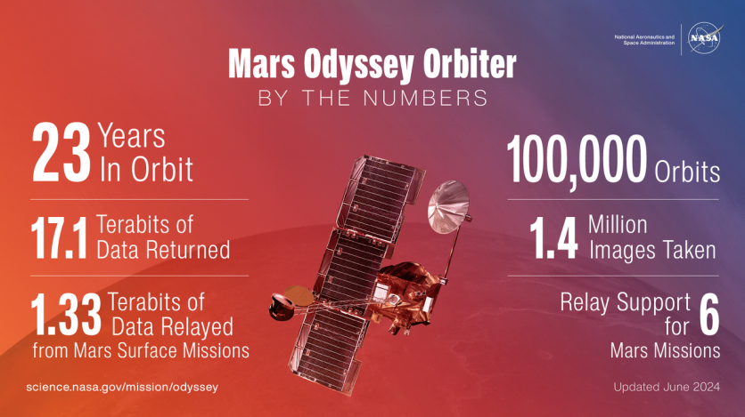
NASA's Mars Odyssey robotic spacecraft, which has been exploring Mars for over two decades, is set to complete an impressive milestone on June 30: 100,000 orbits around the Red Planet.
Since its launch 23 years ago, Odyssey has been pivotal in mapping Martian minerals and ice, determining future landing spots, and transmitting data from various Mars missions.

NASA Mars Odyssey Robotic Spacecraft Captures Olympus Mons: The Tallest Volcano in the Solar System
The camera of NASA's longest-lived Mars robot recently captured a fascinating new image of Olympus Mons, the tallest volcano in the solar system. This image is part of an ongoing effort by the Odyssey team to provide high-altitude images of Mars' horizon.
These images will ultimately help scientists study the planet's clouds and dust. According to NASA, the volcano has a sprawling base of 373 miles (600 kilometers) and a peak of 17 miles (27 kilometers) high.
Jeffrey Plaut, Odyssey's project scientist at NASA's Jet Propulsion Laboratory in Southern California, explained that this new perspective offers a comprehensive view of the volcano, highlighting its massive size.
This image not only captivates visually but also delivers valuable scientific data. These horizon images allow scientists to observe Martian atmospheric conditions across different seasons. For example, a bluish-white band at the bottom of the atmosphere in the image suggests dust levels during early fall, when dust storms typically start.
The purplish layer above is likely a combination of Martian red dust and bluish water-ice clouds. According to NASA, the blue-green layer towards the top indicates water-ice clouds extending up to about 31 miles (50 kilometers) into the sky.
The robotic spacecraft recorded this scene with a heat-sensitive camera called Thermal Emission Imaging System (THEMIS), which was created and managed by Arizona State University in Tempe.
Read Also : NASA Tests Future Mars Helicopter Designs on Earth and Red Planet, Getting the 'Best of Both Worlds'
NASA Odyssey's THEMIS Views the Horizon of Mars
This horizon imaging experiment was conceived during NASA's Phoenix mission landing in 2008 and the Curiosity rover landing in 2012.
According to NASA, Odyssey was essential for relaying data during these events as the spacecraft descended to the Martian surface. The THEMIS camera usually points straight down, so adjusting its angle requires adjusting the position of the whole spacecraft.
Thus, Odyssey's antenna had to be directed toward the arriving spacecraft and its landing site to transmit critical engineering data back to Earth. This alignment positioned THEMIS towards Mars' horizon, prompting scientists to activate the camera and capture images of the scene.
Steve Sanders, Odyssey's mission operations spacecraft engineer at Lockheed Martin Space in Denver, noted that based on these initial experiments, they designed a sequence that keeps THEMIS' field-of-view centered on the horizon as Odyssey orbits Mars.
Lockheed Martin, which built Odyssey, continues to assist with its daily operations alongside the mission leads at JPL.
"Normally we see Olympus Mons in narrow strips from above, but by turning the spacecraft toward the horizon we can see in a single image how large it looms over the landscape," Plaut said in a statement. "Not only is the image spectacular, it also provides us with unique science data."
Related Article : NASA's Hubble Space Telescope Captures' Butterfly Nebula' In Stunning Motion | Fun Facts About This Beautiful Space Butterfly

ⓒ 2025 TECHTIMES.com All rights reserved. Do not reproduce without permission.


