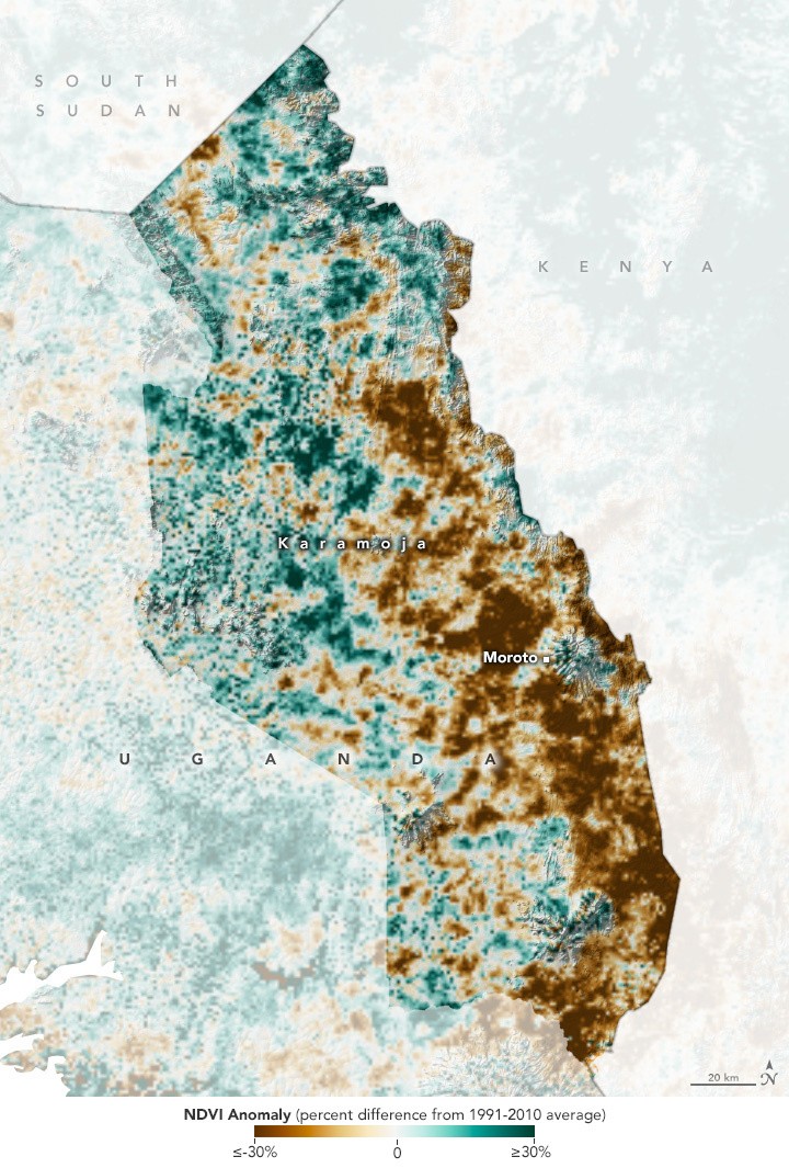
NASA's satellites have provided a stark view of the severe drought gripping the rural Karamoja region in northeastern Uganda. This prolonged dry spell, which commenced in early 2022, has led to the fourth consecutive year of poor harvests in the area, according to NASA.
The Karamoja community heavily relies on small-scale subsistence farming, with productivity closely linked to rainfall. The arid region experiences highly variable precipitation patterns, further exacerbating the impact of the drought.

Normalized Difference Vegetation Index
Using the Normalized Difference Vegetation Index (NDVI), a satellite-derived metric for assessing crop conditions, NASA's imagery illustrates the deviation in vegetation health for the Karamoja region in August 2023 compared to the average NDVI from 1991 to 2010.
It is worth noting that NDVI measures the vitality, or "greenness," of vegetation based on light reflection in the red and near-infrared spectrum.
Catherine Nakalembe, a geographical scientist at the University of Maryland and the NASA Harvest Africa Lead emphasized the challenges faced by farmers in Karamoja. Typically cultivating small plots of 2 acres or less, they grow crops like sorghum, maize, beans, and vegetables, primarily for personal consumption.
Even in years with regular rainfall, yields remain low due to poor soil quality, limited irrigation, and a lack of fertilizers. Nakalembe pointed out that many households struggle to produce enough food for self-sufficiency, often depending on food aid. Drought exacerbates these difficulties by causing crop failures.
Nakalembe's research highlights the significance of August's NDVI values in gauging conditions throughout the growing season. "The vegetation health in August integrates the effects of rainfall deficits over the critical crop growth stages," she explained.
The rainy season in Karamoja during 2023 was characterized by erratic and below-average rainfall, punctuated by prolonged dry spells from April to August, according to the Famine Early Warning Systems Network (FEWS NET). Particularly, the eastern part of the region experienced significant rainfall deficits from June to August.
NASA notes that the consequences of the subpar harvest, livestock losses, and the diminished ability of the population to cope are anticipated to result in crisis-level outcomes, as per the Integrated Food Security Phase Classification system.
This phase, known as Phase 3, is marked by heightened levels of acute malnutrition and difficulties in meeting basic food requirements.
Read Also : NASA's James Webb Discovers New, Never-Before-Seen Feature in Jupiter's Atmosphere-What Is It?
NASA's Harvest Program
The NASA Harvest program aims to utilize satellite-based Earth observations to improve crop production, food security, and various agricultural practices. One example is the Global Agriculture Monitoring System (GLAM), which allows both experts and non-experts to track the condition of croplands worldwide with nearly real-time updates.
Furthermore, the GEOGLAM Crop Monitor for Early Warning project is dedicated to forecasting potential reductions in crop yields by examining data from satellites related to vegetation and weather patterns.
Related Article : NASA Ingenuity Helicopter Takes 54th Flight; Video From Perseverance Mars Rover Shared on National Aviation Day

ⓒ 2025 TECHTIMES.com All rights reserved. Do not reproduce without permission.


