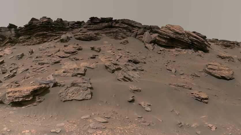
Perseverance, a brand-new Mars rover, is very powerful when it comes to revealing the planet's landscape in exquisite detail.
It recently unveiled a fully functional Mars unit brimming with 2.5 billion pixels worth of sand, rocks, sky, and rover pieces.
On September 14th, NASA released the most detailed image of the Martian surface ever taken, as reported first by Interesting Engineering.

Sights and Sounds of the Jezero Crater
NASA also published a video tour of the image along with the images. The video's narrator, Rachel Kronyak, a member of the perseverance scientific operations team, takes viewers through the sights and sounds of the Jezero Crater, which is considered an ancient river delta site.
The video immerses you into the Martian cliffs, sedimentary rocks, hills, rover trails, and sample collection sites.
The pixels in this image eclipsed the 1.8 billion-pixel panoramic photo of the Gale Crater taken by the Curiosity rover in 2020.
The Mastcam-Z, a head-mounted camera made specifically for this kind of photography, was used to take the 1,118 individual photographs that make up this collection. The pictures were recently taken between June 12 and June 20.
The full resolution, color-processed photograph from NASA weighs in at a massive 3.85 gigabytes.
This enables rover enthusiasts to scrutinize every small aspect and learn more about the Martian landscape. The space agency presented a briefing on Perseverance's first 1.5 years on Mars on Thursday before they released the video tour.
Are There Signs of Life on the Jezero Crater?
Due to its history of water flow, the delta where the photographs were shot is a significant location for exploration. Perseverance is expected to provide some answers for NASA on the existence of microbial life on Mars.
At the delta, the Rover gathers materials that NASA will analyze once it returns to Earth.
NASA selected Jezero Crater as the landing area for the Perseverance rover. Scientists claim that the area was formerly submerged in water and was the location of an ancient river delta.
Scientists from all over the world and members of the mission crew worked together to evaluate more than 60 potential landing sites on Mars thoroughly.
Jezero emerged as the best option after a comprehensive five-year analysis of potential sites, each with its own distinctive qualities and attraction, as noted by NASA.
The story of Mars' on-again, Jezero Crater, reveals an off-again wet past. River channels burst over the crater wall and formed a lake more than 3.5 billion years ago.
There is proof, according to scientists, that water transported clay minerals from the surrounding area into the crater lake. Jezero may have supported microbial life during one or more of these wet periods, according to NASA.
Related Article : 'Largest Canyon in The Solar System:' ESA's Mars Express Snaps Stunning Views of Mars's Grand Canyon
This article is owned by Tech Times
Written by Joaquin Victor Tacla
![Apple Watch Series 10 [GPS 42mm]](https://d.techtimes.com/en/full/453899/apple-watch-series-10-gps-42mm.jpg?w=184&h=103&f=9fb3c2ea2db928c663d1d2eadbcb3e52)


